What Is a Point Cloud?
A practical explanation of point cloud data, how it is captured, what it can and cannot do, and how clients use it.
A point cloud is not a CAD drawing; it is a permanent 3D factual record of your building composed of millions of laser measurements. While you cannot edit it like a floor plan, it serves as an interrogable digital twin that eliminates return site visits.
If you have commissioned a laser scan survey, or are about to, and the surveyor has mentioned that you will receive "the point cloud" alongside your drawings, and you have nodded as though you know what that means while privately imagining something between a weather system and a spreadsheet, this article exists to resolve that ambiguity without requiring you to develop an interest in photogrammetry or LiDAR physics.
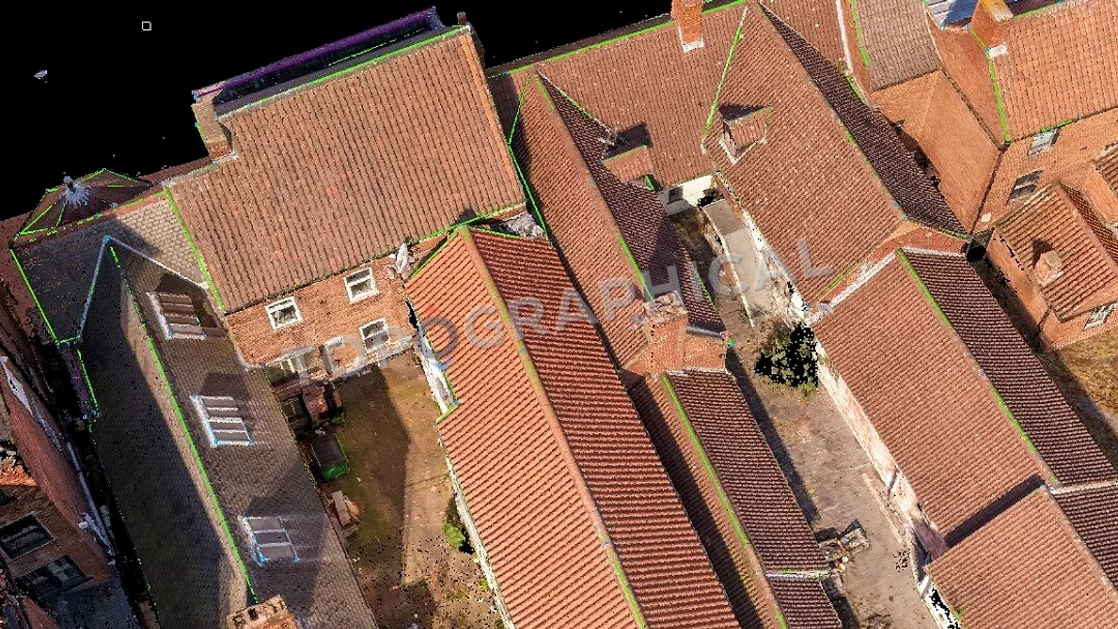
A point cloud is, in the most literal and useful sense, a collection of measured points in three-dimensional space. Each point has an X coordinate, a Y coordinate, and a Z coordinate (and frequently a colour value captured from an integrated camera). When several million of these points are collected across the surfaces of a building or a site, and displayed together on screen, they form a three-dimensional representation of whatever the scanner could see: walls, floors, ceilings, ground surfaces, trees, fences, furniture, cars, and everything else that was physically present and visible at the time of capture.
It looks, when you first open it, like a photograph that has been shattered into confetti and then frozen in space. Zoom in, and individual points become visible. Zoom out, and it is indistinguishable from a high-resolution 3D photograph of the environment. Rotate it, and you can examine the subject from any angle, including angles that no photograph could capture because no camera was positioned there.
How a point cloud is created
Two primary methods produce point clouds relevant to surveying:
Terrestrial laser scanning places a device (roughly the size of a thermos flask on a tripod) at multiple positions within or around a building or site. At each position, the scanner emits a laser pulse that sweeps across its full field of view, measuring the distance to every surface the beam hits, millions of times per second. Each measurement becomes a point. The scanner is then moved to the next position, and the process repeats. The individual scans are registered together (aligned into a common coordinate system using overlapping geometry and survey-grade control points), producing a single, unified point cloud of the entire subject.
Photogrammetry (including drone capture) takes overlapping photographs of a subject from multiple positions and uses software to calculate the three-dimensional position of features visible across multiple images. The result is also a point cloud, though typically with a different density distribution and accuracy profile to laser scanning. For topographic surveys of open land, drone-derived point clouds are an efficient capture method. For buildings and enclosed spaces, laser scanning remains the primary tool because it does not depend on ambient light or photographic texture.
Photogrammetry (including drone capture) takes overlapping photographs of a subject from multiple positions and uses software to calculate the three-dimensional position of features visible across multiple images. The result is also a point cloud, though typically with a different density distribution and accuracy profile to laser scanning. For topographic surveys of open land, drone-derived point clouds are an efficient capture method. For buildings and enclosed spaces, laser scanning remains the primary tool because it does not depend on ambient light or photographic texture.
Point Cloud Data vs. 2D CAD Drawings
| Characteristic | 3D Point Cloud | 2D CAD Drawing (DWG) |
|---|---|---|
| What it is | Millions of raw XYZ laser measurements | Clean, interpreted linework (walls, floors) |
| Level of Detail | Captures everything visible | Shows only what was requested in the brief |
| Editability | Cannot be easily modified or "stretched" | Fully editable by architects and engineers |
| Future Value | High (Extract new dimensions anytime) | Static (Limited to the initial view) |
What a point cloud is not
A point cloud is not a drawing. It is not a CAD file. It cannot be opened in AutoCAD and edited as linework. It is raw measured data: a three-dimensional record of surface positions, without interpretation, without layers, without the conventions of plan, elevation, or section. It contains no walls (only the points that describe where wall surfaces are). It contains no floor levels (only the points that describe where the floor surface is). The act of interpreting that raw data into conventional 2D drawings (identifying which cluster of points represents a wall, measuring its thickness, establishing its relationship to other walls, and drawing it as a line on a floor plan) is the skilled office work that a measured building survey comprises.
This distinction matters because it defines what you can and cannot do with a point cloud without further professional input:
You can: View it, rotate it, take approximate measurements between visible surfaces, produce visual screenshots from any angle, generate section slices at any position, and use it as a spatial reference when designing in software that supports point cloud overlays (Revit, ArchiCAD, AutoCAD with ReCap, SketchUp with plugins).
You cannot: Extract accurate 2D drawings from it without surveying expertise and appropriate software. The translation from point cloud to floor plan requires professional judgement about what constitutes a wall line (inner face of plaster? structural face of brick? average of an undulating surface?), how to represent features that are three-dimensional in a two-dimensional convention, and where to place the section cut that best describes the space.
Why the point cloud persists as a project asset
When we deliver a measured building survey, the drawings you receive (floor plans, elevations, sections in DWG format) are the primary deliverable: the thing your architect or engineer opens and works from on a daily basis. But the point cloud from which those drawings were extracted does not disappear. It persists as a permanent, interrogable record of the building or site at the time of capture.
This means that if, at any subsequent project stage, someone requires a piece of dimensional information that was not included in the original drawing specification (a soffit level in a corridor that was not sectioned, a window reveal depth that was not dimensioned, a wall thickness at a location that was not detailed), that information can be extracted from the point cloud without a return visit to site. The additional extraction is office work, priced accordingly, and delivered in days rather than the weeks that a new site booking would require.
For projects where the brief evolves (and they all do, because architects are iterative creatures working for clients who change their minds), this persistence transforms the survey from a one-time deliverable into a spatial database that the project can query repeatedly. The cost of capture happens once. The value extracted from it compounds over the project's life.
File formats and what to ask for
Point clouds are delivered in standardised formats. The most common are:
- E57: An open, vendor-neutral format that almost all point cloud software can read. If in doubt, ask for E57.
- RCP/RCS: Autodesk's indexed format, optimised for use within Revit, AutoCAD, and Navisworks. If your design team works in the Autodesk ecosystem, this is what they want.
- LAS/LAZ: Common for topographic and aerial survey point clouds. LAZ is the compressed version of LAS.
- PTS/PTX: Older formats from Leica systems, still widely used.
If you are not sure which format to request, tell your surveyor which software your design team uses. The correct format follows from that information, and asking for it at the point of commission (rather than after delivery) avoids a reformatting exercise that benefits nobody.
The practical summary
A point cloud is the evidence. The drawings are the interpretation. You need both: the drawings for daily design work, and the point cloud for the inevitable moment (three months into the project, when the mechanical engineer needs a dimension that nobody anticipated at briefing stage) when the evidence needs to be re-examined. The cost of having both is the cost of having one, because the point cloud is captured in the same site visit that produces the drawings. It is not an add-on. It is the method by which the drawings are produced, retained as an asset rather than discarded as a by-product.
Frequently Asked Questions (FAQ)
Can I open a point cloud in AutoCAD or Revit? Yes. Modern CAD packages (like Revit, ArchiCAD, and AutoCAD via ReCap) allow you to import the point cloud and use it as a 3D visual reference to draw over.
Why don't I just get the point cloud instead of 2D plans? Because you cannot easily edit a point cloud or send it to a builder. You pay a surveyor to professionally interpret the massive point cloud data into clean, usable 2D floor plans and sections.
What file format should I ask for? If you use Autodesk (Revit/AutoCAD), ask for RCP/RCS. If you use alternative software, ask for E57, which is the universal, vendor-neutral standard.
Ready to brief a survey?
Draw your site, define the scope, and receive a fixed-price quote.
Start a Survey Quote