Your Title Plan Is Not a Boundary Survey
Why Land Registry title plans show general boundaries only, and why measured site features are needed for design or boundary-sensitive work.
Stop trying to measure boundaries from a Land Registry title plan. Title plans only show general extents at a 1:1250 scale; to establish the true physical limits of your site, you must commission a topographic survey to capture exact boundary feature coordinates.
At 1:1250 scale (the standard for urban Land Registry title plans), one millimetre on paper represents 1.25 metres on the ground. The thickness of the red line that HM Land Registry uses to indicate "the general position of the boundaries" is itself approximately 0.3mm, which means the boundary as drawn could sit anywhere within a 375mm corridor of physical space. For a terrace house with a 5-metre frontage, that ambiguity represents nearly eight percent of the property's width. For a rear garden where the fence is 300mm from where the neighbour believes it should be, the title plan cannot resolve the dispute, because it was never designed to, and the disclaimer printed on every official copy states this with admirable clarity: "This title plan shows the general position of the boundaries: it does not show the exact line of the boundaries. Measurements scaled from this plan may not match measurements between the same points on the ground."
That disclaimer is not defensive legal hedging. It is a factual statement about the limitations of a document produced by plotting property extents onto Ordnance Survey mapping at a scale designed for cadastral indexing rather than engineering measurement.
What the title plan actually is (and what it is not)
The Land Registry title plan exists to show which land is included in a registered title. It serves an index function: identifying, at a general level, the physical extent of the property registered under a given title number. It is plotted onto the OS base map at the time of first registration, using whatever information was provided to the Land Registry by the conveyancer handling the transaction.
It is not a measured survey of the property boundaries. It is not evidence of where the legal boundary lies to sub-metre accuracy. It is not updated when physical boundary features (fences, walls, hedges) are moved, replaced, or removed. And it is not capable of resolving a dispute where the contested distance is less than approximately 500mm, because the plotting tolerance of the plan exceeds that distance.
The OS base map underneath the title plan shows physical features that existed at the time of the relevant OS survey revision. Ordnance Survey is explicit that its maps "record physical features according to the then current OS specifications, not legal boundaries" and that "if a feature is shown on an OS map it means that the feature existed, whereas the reverse is not always true." A fence that has since been moved, a hedge that has been removed, a wall that has been rebuilt on a slightly different line: none of these changes necessarily appear on either the OS map or the title plan derived from it.
Where the confusion causes damage
The typical sequence is: a homeowner wishes to build an extension and commissions an architect. The architect obtains the title plan and uses it as the basis for the site plan submitted with the planning application. A neighbour objects, claiming the extension is closer to the boundary than shown. The homeowner points to the title plan. The neighbour points to the fence. The fence does not align with the title plan (because it was never intended to). The dispute escalates.
Alternatively: a developer acquires a site and instructs their architect to design to the title plan boundary. The design assumes the full extent shown on the title plan is available. When a topographic survey is eventually commissioned, it reveals that the physical boundary features (which have existed for decades and represent the agreed operational boundary between neighbours) sit 400mm inside the title plan extent. The site is narrower than designed to. The scheme no longer fits.
In both cases, the problem is not that anyone acted maliciously. It is that a document designed for cadastral indexing was used as though it were a measured survey, and the difference between those two functions manifested as a dispute, a redesign, or both.
What a topographic survey tells you about boundaries
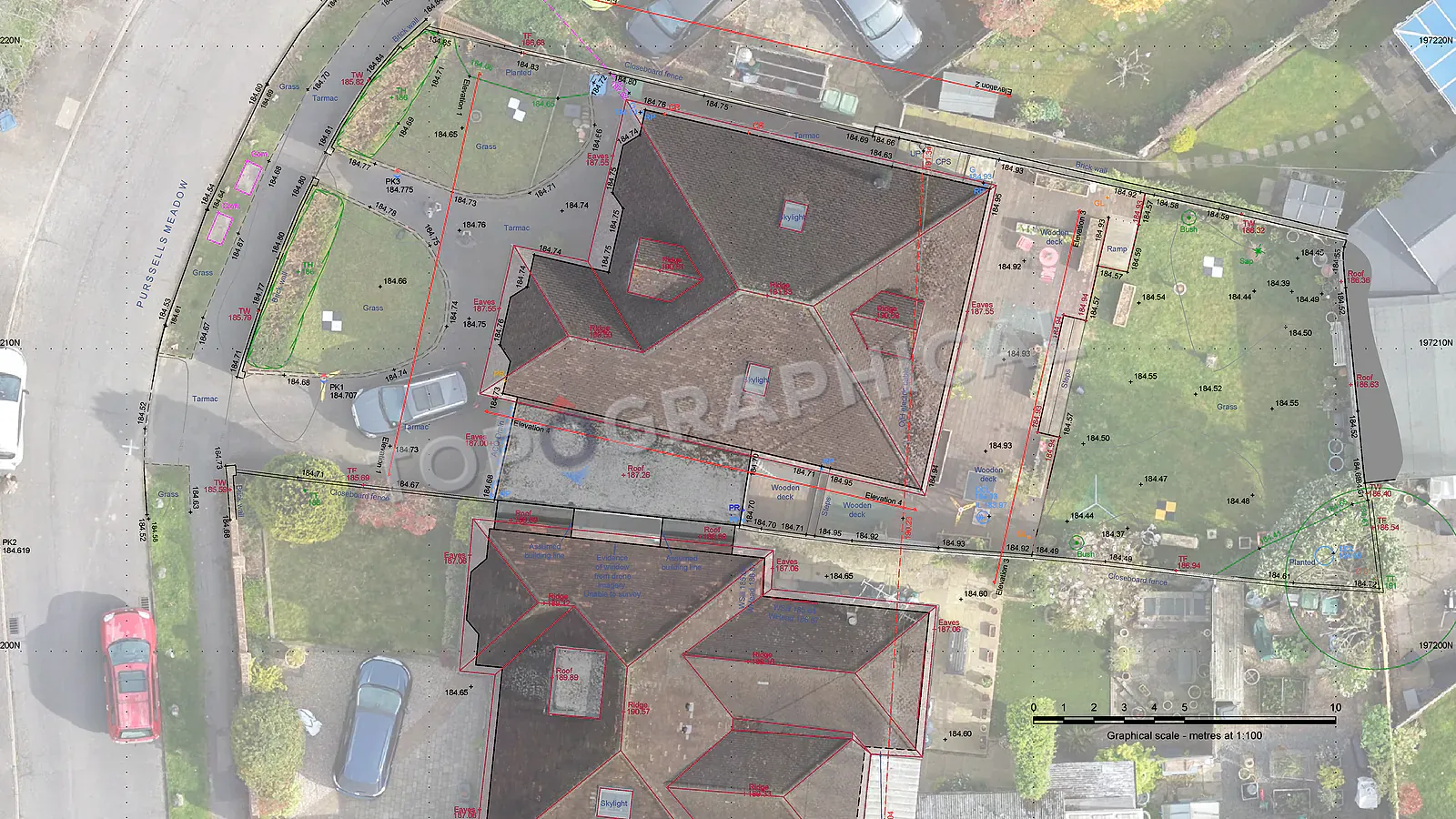
A topographic survey records the physical position of boundary features as they exist on the ground at the time of survey: fence posts, wall faces, hedge lines, kerb lines, and any other physical demarcation between adjacent properties. It measures their position in a coordinate system with stated accuracy (typically plus or minus 10mm to 20mm for boundary features), which means you know where the fence is, relative to the building, the road, and other fixed features, with a precision approximately fifty times greater than what the title plan can provide.
What the topographic survey does not tell you is where the legal boundary lies, because the legal boundary is not a physical feature. It is a legal construct defined by the conveyance, the transfer deed, and (where applicable) historical usage, and its relationship to the physical features on the ground requires legal interpretation, not measurement.
However, for the purposes that most clients actually need (designing an extension that respects the physical site constraints, demonstrating to a planning authority that a proposal sits within the developable area, or identifying where the current fence line sits relative to buildings and features), the topographic survey provides the measured certainty that the title plan cannot.
Land Registry Plan vs. Topographic Survey
| Feature | Title Plan | Topographic Survey |
|---|---|---|
| Accuracy Standard | "General position" (approx. 500mm tolerance) | Sub-centimetre (±10mm to 20mm) |
| What it Shows | Legal title extent at time of registration | Physical reality on the ground today |
| Updates | Rarely (unless formally changed) | Captures every current fence, wall, and hedge |
| Role in Design | Unsuitable for architectural planning | Essential foundation for design boundaries |
When you actually need a boundary determination
If a dispute has escalated to the point where parties cannot agree on where the legal boundary sits, and the matter cannot be resolved by reference to the original conveyance plans, title deeds, and physical evidence, then an application for a "determined boundary" under Section 60 of the Land Registration Act 2002 may be appropriate. This is a formal process requiring expert evidence, detailed plans, and (frequently) tribunal proceedings if the neighbouring owner does not consent.
A topographic survey provides the measured spatial framework on which boundary evidence is plotted and presented, but the legal determination itself is beyond the scope of a surveying commission. It requires a boundary specialist (typically a chartered surveyor with specific experience in boundary disputes and the relevant RICS professional standard) who interprets the historical and physical evidence within the legal framework.
For the vast majority of development projects, this level of investigation is unnecessary. What is necessary is a topographic survey that shows the physical features accurately, overlaid with the title plan extent so that any discrepancy between the two is visible, quantified, and can be addressed at design stage rather than discovered on site during construction.
The practical recommendation
Commission the topographic survey. Ask for the title plan boundary to be plotted onto it as a layer (the surveyor overlays the Land Registry extent onto the measured plan, so you can see visually how the title plan relates to the physical features). If the two align within reasonable tolerance, proceed with confidence. If they do not, identify the discrepancy before you design to an extent that may not be available to you, and seek appropriate advice (legal, not surveying) on which boundary represents the developable limit.
The cost of discovering this discrepancy at design stage is a conversation with a solicitor. The cost of discovering it during construction, when the neighbour's surveyor demonstrates that your foundation trench is 200mm over the line they are prepared to defend, is measured in injunctions, party wall disputes, and the sound of a project programme tearing itself in half.
Frequently Asked Questions (FAQ)
Can I scale up a Land Registry title plan to check my boundary? No. At 1:1250 scale, the thickness of the red line on the plan covers nearly 400mm of physical ground. It cannot resolve precise boundary lines.
Does a topographic survey tell me exactly where my legal boundary is? No. It maps the physical features (fences, walls) to extreme accuracy. Comparing this physical survey to the title plan helps identify discrepancies for a solicitor to resolve.
What happens if I design my extension based on the title plan? You risk assuming you have more land than the physical boundary allows. Discovering this during construction usually results in party wall disputes, redesigned foundations, and project delays.
Ready to brief a survey?
Draw your site, define the scope, and receive a fixed-price quote.
Start a Survey Quote