
Photo by Alexander Andrews
*** As of January 2024, we have withdrawn our services relating to boundary surveys. Thank you to all that have worked with us over the years. We'll leave this page online for information purposes but please note that the content will not be checked or updated ***
Boundary surveys can vary in scope depending on the reason for the survey. Our experience ranges from splitting up parcels of land and preparing title plans for Land Registry, to undertaking boundary analysis surveys and providing CPR 35 compliant expert reports to the courts in the resolution of boundary disputes.
Each project is different and a boundary survey can be customised to your requirements however most boundary surveys usually fall into one of the following categories: -
Land Registry Administration
Transfer Plans - A land registry compliant plan is required as part of the conveyancing process when the ownership of land changes. Most land is already registered, but it may be that the land is being split up (transfer of part) or it is unregistered land (first registration), and a land surveyor is required to create a sufficient drawing.
Boundary Agreements - In many cases, an agreement about the legal position of, or the obligation to maintain a boundary, can be registered in writing without the need for a plan. Where required, a measured survey of the boundary can be undertaken, to provide a supporting scale plan. Read about Boundary Agreements on the Land Registry Website
Determined Boundaries - In cases where the exact line of a boundary has been agreed between all owners concerned, an owner may apply for a determined boundary to create a record of this in the register. Sufficient evidence will be required and this will usually be in the form of an accurate, scale drawing with annotated measurements or coordinates, signed by all parties.Read about Determined Boundaries on the Land Registry Website.
Boundary Analysis
Measured Boundary Survey & Analysis -
**Due to the huge increase in residential boundary dispute enquiries over the last year of lockdown, we are no longer providing a service in this area, so that we may continue to serve our regular clients**
We can undertake a measured boundary survey, to a high degree of accuracy and capture the position of the physical features making up and/or relating to a boundary. If a boundary is likely to be disputed, we would always advise taking legal counsel, as there may be sufficient evidence to make your case without needing to instruct a land surveyor.
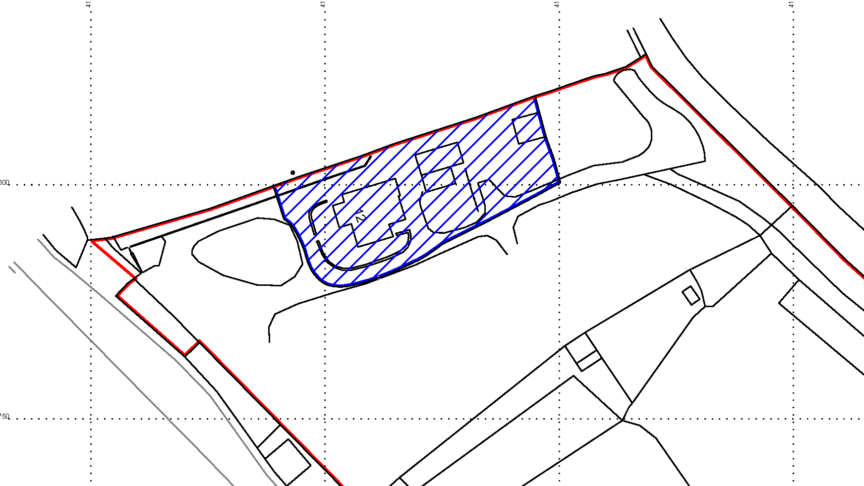
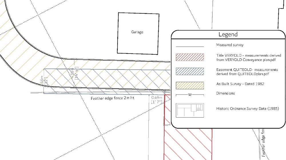
A boundary analysis may be instructed by a single party who suspects an anomaly but does not want to incur legal costs at such an early stage. The measured survey is used as a base model, showing what is currently being treated as the boundary on a site (the physical boundary). We can then overlay historic imagery, title (deed) plans or Ordnance Survey data to highlight any discrepancies. In some cases, the title plan is explicit about the measurements of a parcel of land, right of way or easement. Overlaying these measurements graphically on the measured survey can create compelling evidence to be used in negotiation and/or litigation.
**Due to the huge increase in residential boundary dispute enquiries over the last year of lockdown, we are no longer providing a service in this area, so that we may continue to serve our regular clients**

Boundary Disputes
Solicitors Instruction - Where a boundary is already in dispute, we take enquiries from solicitors or the courts to produce an Expert Report and/or plans to be used in civil proceedings.
Boundary Reinstatement
Setting Out
Sometimes a physical boundary feature can be lost on the ground over time and an owner may wish to have it reinstated, often in advance of redevelopment or transfer of ownership. Evidence of a former physical boundary will be required, to enable the boundary to be coordinated. This might come from an Ordnance Survey (OS) map/title deed/register plan or historic design/as built drawings. We can set out this position on the ground, marked using an appropriate marker such as spray, flags, stakes or string line. Depending on what information is available, a boundary surveyor may need to make an initial site visit before preparing the coordinates to set out on a return visit.
A physical boundary may not coincide with the legal boundary and when reinstating a boundary based on OS mapping data, it is worth noting the accuracy of the original OS survey is typically lower than peoples expectations.
Here is a table reproduced from Ordnance Survey, showing the results of four decades of accuracy testing on their large scale topographic mapping data. As a general guide, urban areas were typically surveyed at 1:1250, rural/agricultural areas at 1:2500 and larger areas, such as mountainous terrain at 1:10,000. Without going into the nuances of relative and absolute accuracy and RMSE these figures may come as quite a surprise to homeowners poring over their title plans with a scale rule.
Ordnance Survey mapping accuracies of large scale topographic mapping data
Original survey scale | 99% confidence level | 95% confidence level | RMSE* |
1:1250 | |||
Absolute accuracy | 0.9m | 0.8m | 0.5m |
Relative accuracy | +/- 1.1m (up to 60m) | +/- 0.9m (up to 60m) | +/- 0.5m (up to 60m) |
1:2500 | |||
Absolute accuracy | 2.4m | 1.9m | 1.1m |
Relative accuracy | +/- 2.5m (up to 100m) | +/- 1.9m (up to 100m) | +/- 1.0m (up to 100m) |
1:10 000 | |||
Absolute accuracy | 8.8m | 7.1m | 4.1m |
Relative accuracy | +/- 10.1m (up to 500m) | +/- 7.7m (up to 500m) | +/- 4.0m (up to 500m) |
(Confidence level is how frequently a parameter falls within the quoted limits.) *RMSE (root mean square error) is the square root of the mean of the squares of the errors between the observations.
Source Ordnance Survey © Crown copyright 2014
Back to Services, including Topographic Surveys, Setting Out, & Measured Building Surveys