
As a percentage of overall development cost, the topographic land survey cost is typically very low, whilst it remains a critical data set relied on throughout planning, design and construction.
For this reason, it's common for clients to take a low risk approach and request large general areas to be surveyed by their regular trusted land surveyors, using standard (pretty thorough) specifications. This allows greater flexibility should obstacles be encountered at the design stage; through not having to re-instruct a land surveyor to extend the survey or add detail.
But for those looking to control a particularly tight budget, the land survey is of course another area which can come under scrutiny. It may also be the case that a site is to be sold before design and construction takes place. In this case, a client may choose to commission a cheaper survey that doesn't stand-up to detailed design by other parties further down the line. This may well be perfectly adequate for obtaining planning permission prior to sale.
We're here to offer some tips and guidance on how you can both decrease the cost of your land survey and maximise the value received from the land surveyor you choose.
1. Clearly explain the purpose of the survey
If you're an expert on survey specifications, and know how the different disciplines in the planning, design and construction sectors use topographic survey data, that's great. You'll be able to obtain specific and relevant quotes that offer the best value for money for the process that you will be involved with- by producing your own survey specification. There's less need to go into the details of how the survey will be used though it can still be helpful.
If you're not as clued up on this and need some guidance building the specification, please tell your land surveyor what it is you are planning to do. Often, the professions that use topographic survey data are instructed after procuring the topographic land survey and so you may not have the benefit of their advice. You can expect that your land surveyor has worked on a project just like yours, and can provide a common starting point for similar scenarios whilst understanding which areas are likely to be critical and which areas less so.
You should consult the professionals that will use the data where possible, whether this is a planning consultant, architect or engineer that you intend to instruct or have instructed already.
2. Clear the site and provide open flexible access
When a land surveyor attends a site which is cluttered, messy, densely vegetated or otherwise obscured, both the quantity and quality of data is likely to suffer. You pay a land surveyor to bring their skill and expensive survey equipment to your site. You don't want to pay a land surveyor to cut down vegetation, move rubbish or leave areas un-surveyed due to insufficient access or visibility.
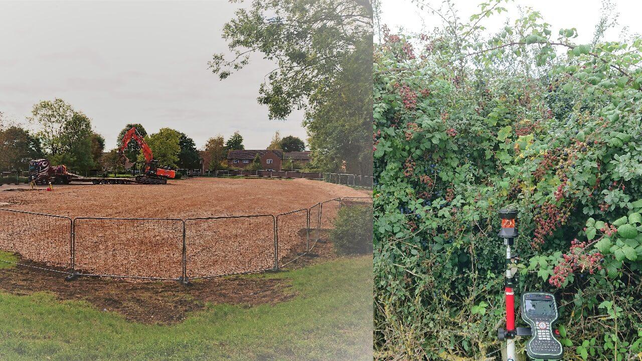
Ensure the key areas where survey data is needed, have been physically cleared if necessary. This may not always be possible due to mis-timed ecology surveys. If you have a clear open site already, be sure to provide pictures and highlight this to the land surveyor as it may not be obvious from Google Maps/Earth/Street View.
If possible, provide open and flexible access. Access can hamper survey progress considerably. Being flexible about access means your site can jump to the front of the queue if the land surveyors schedule opens up before your scheduled site visit.
3. Remove unwanted area from the survey
It's easy to draw a line on a map to outline a survey area for a topographic survey. Moving that line just a few metres could mean the difference of several hundred or even thousands of pounds.
Adjacent/Access Roads
Do you really need the access road in full topographic detail, or would cheaper Ordnance Survey data be suitable for current purposes?
Irrelevant Land
Just because you are buying or obtaining an option on a parcel of land, doesn't mean you will be able to develop all of it. Figure out which parts of the site are critical and ask for a land survey quote for this area only, rather than the whole title.
4. Remove unnecessary detail from less important areas
"Detail" refers to the features surveyed by the land surveyor and shown on your topographic survey. It includes natural features like slopes, banks, depressions trees and vegetation and man made features like concrete, fences, walls and buildings.
A standard topographic survey specification will call for a comprehensive level of detail across the whole survey. This will vary slightly from firm to firm so check what's included too.
Split your survey up where possible to separate the areas where less detailed information is required: -
Splitting areas example
Area A: - Development area - full topographic detailing
Area B: - Flood Plain - Spot levels only + 1 m contours

Trees have the potential to really slow down a topographic land survey. If you've accounted for Conservation Areas and Tree Protection Orders and you only need specific trees locating - then considerable time savings can be made depending on the site.
Data on trees is often required to map the root protection zones of protected trees (or candidates) that may impact on any proposed development.
These are two examples of details sometimes "over-surveyed" by land surveyors and their clients. It's great to have a wealth of data, consistently measured, just in case someone needs it at some point. Unfortunately, it is not always cost effective, necessary or accomodated by budgets. Take a look at the itemised list of features your surveyor is proposing to include within the cost of the land survey. Are some of these irrelevant to your purpose? Are the irrelevant features common on your site? This gives you the potential to negotiate a lower cost land survey.
5. Choose a reputable surveyor
The old adage "Do it right or do it twice" applies to topographical land surveys as much the next professional service. It doesn't matter how cheaply you manage to acquire a land survey, if it's not fit for purpose. Other professions whose work relies on it, will demand that the survey is recommissioned.
The RICS (Royal Institute of Chartered Surveyors) are the principal governing body for land surveyors in the UK, along with the CICES (Chartered Institution of Civil Engineering Surveyors). Many reputable firms have chartered members and are regulated by the RICS.
Some firms advertise the same and use these logos without any such affiliation and may or may not be able to deliver the same level of service and professional indemnity insurance.
Ask for sample drawings. If you're not the end user, check with whoever is that the the specification covers all their needs and that the drawing samples meet their usual standards.
6. Consider turnaround time - time is money
Turnaround time can be a critical factor in determining if a land survey quote offers value for money. It may not be the cheapest quote, but if it means "in house" designers can get started on the next project sooner, it could save money in payroll overall.
Likewise, if you are in no particular rush, make this clear to your land surveyor. Prices are likely to be most competitive when not subjected to intense time pressures, which can result in late working and staff overtime costs.
